Descripción
GPS INSTRUMENTS
Marine GPS
The gps sea is part of our product guide the implementation of the sub-category gps, tools
Find great prices on our website www.aguamarket.com
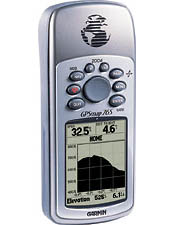
Marine GPS map for you, this unit incorporates a barometric altimeter and an electronic compass which report the precise location, elevation, and twist information to lead the adventurer as high and far as he wants to go, feeds on 2 AA batteries . Battery life (up to 16 hours).
The maritime GPS also contains a base map that includes roads of America, including highways, streets, political boundaries, oceans, lakes, rivers, cities, roads and highways and borders, comes preloaded with world cities to aid navigation and data of America and USA, also has 24mb of memory to download data, is waterproof and floats in water, has a larger screen, larger buttons and a more rugged design that allows use in even the most austere conditions.
Marine GPS Includes:
- Mapping: Pacific Highway.
- PC connection cable.
- Belt.
- User Manual (Spanish and English).
- Quick reference card.
GPS Navigation Features Maritime:
The marine gps waypoints has a 500 with name and icon, 50 reversible routes of 50 waypoints each plus MOB and thus save up to 10 track allowing you to redo your steps in both directions, shows the current speed, average, high travel time and distance and includes tables indicating the best times to fish, hunt, hours of sunset and the moon.
Marine GPS Features:
- Receives and continually using data up to 12 satellites to compute and update position.
- Acquisition times:
- Warm: approx. 15 seconds.
- Cold: approx. 45 seconds.
- Ratio of Update 1 second continuously.
- Accuracy of GPS position <15 meters, 95% chance.
- Position: 3-5 meters, 95% chance.
- Velocity: 0.05 meter / sec.
- Accuracy DGPS (WAAS).
- Dynamics: 6g’s.
- Connection for external antenna (MCX connector).
- Benefits of the electronic compass.
- Pressure: + 2 degrees (typical), + 5 degrees in extreme northern and southern latitudes.
- Resolution: 1 degree.
- Functions of the barometric altimeter accuracy: 10 feet (3 meters) with self-calibration (user and / or automatic calibration).
- Resolution: 1 foot (33 cm).
- Range: -2000 to 30,000 feet (- 666 to 10,000 meters).
- Computer Height: current height, maximum and minimum height to zero, rate of climb / descent, ascent / total descent, average and maximum rate of climb / descent.
- Pressure: Local pressure (mbar / inches of mercury), 12-hour automatic storage of pressure tendency.
GPS Marine Physical Specifications:
The sea gps has a size of 6.9 x 15.7 x 3.0 cm, a weight of 7.7 ounces, a screen of 4.1 x 5.6 cm A high contrast LCD with backlight 180 x 240 pixels, a robust housing and a temperature range of – 15 º C to 70 º C
Continue browsing our site so that more of our products quote
We invite you to be part of our portal Aguamarket to buy our products and look for topics that are of interest as products, news, tenders, etc..

