Descripción
GPS INSTRUMENTS
GPS Equipment
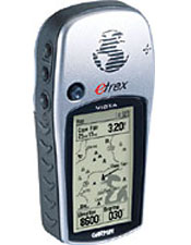
This GPS is the most complete of the family as a single team in the functions of GPS (mapping, database of cities, etc..) And the Summit (barometric altimeter, electronic compass, height profiles, etc.).. Its a small team size for any outdoor activity or in a vehicle traveling on a road or a city.
Find great prices on our website www.aguamarket.com
The Vista can also awards in their memory capacity, no less than 24 megabytes, which allows the view to collect data from maps of the broad line, including silver and it looks a high-tech appearance, GPS mapping with altimeter and electronic barometer. It has a base map of all America with its most important cities and towns, fog and coastal roads, both America and Chile.
GPS equipment includes 3 instruments (GPS, barometric altimeter and electronic compass high precision), on one computer, delivers the users geographic position in latitude and longitude, UTM and other formats, details the journey made Function (Track) and can store reference points (waypoints), guiding the user to these directly (Goto function) or by a previously constructed route. Function (Route), besides being able to guide us through the exact footprint we have made through the TrackBack function.
This GPS device has a 12-channel satellite receiver, calculation of areashas 24 MB of memory capacity that lets you import information mapping: with more detail and points of interest from Garmin Map Source software, has an accuracy between 3 and 15 meters.
Gives information on the position, speed, average speed, maximum speed, altitude, heading, bearing, course line, travel time, departure time course and sunset, distance traveled, distance to destination and estimated time of arrival., allows for a course to a destination visually pointing our where we wish to turn thanks to its electronic compass, and much more since it has more than 65 functions and data.
The altimeter and electronic compass GPS combined to make a real computer the gradient, indicating current height, maximum and minimum elevation and rate of ascent / descent, maximum ascent and descent and a half, vertical speed and altitude graphs delivery every few meters or time, besides being able to display the graph with respect to height and atmospheric pressure.
Collect statistical information on height and downs, its appearance is that of a gray casing and the center key innovative joystick makes handling the GPS still easier and more convenient, storing up to 1000 waypoints and has capacity to store 20 routes of 120 waypoints each, including the Map Datum 56, 69 and 84 used on the maps of Canada, works with 2 AA alkaline batteries give a range of 12 hours, your version is in Spanish.
Features:
- Power supply AA batteries or ext.10-32 v.
- 12 parallel channel receiver.
- Memory 500 wpt.
- Interface NMEA 0183 and DGPS.
- RS232 PC interface.
- Duration batteries up to 12 hours.
- Weight: 150 gr.
- Dimensions 111 x 50 x 35 mm.
Continue browsing our site so that more of our products quote
We invite you to be part of our portal Aguamarket to buy our products and look for topics that are of interest as products, news, tenders, etc..


